How the Sun Moves Through the Sky
The Sun appears to be constantly moving across the sky. How does its path changes from month to month? We know that the Sun rises in the east and sets in the west, but does it rise exactly east and set exactly west every day? We also know that the days are longer in the summer and shorter in the winter. But how is it connected with Sun’s changing path across the sky?
These are some common questions we are all confronted with. And they become all the more relevant when we talk about solar panels’ performance which depends upon their orientation and the angle of tilt. These questions are in fact more relevant for capture of solar thermal power where Sunrays’ are to be concentrated. Life would be very simple if the Sun were to arise and set precisely in the same directions and if it followed exactly same path through the sky everyday throughout the year.
The Path of Sun in Summer and Winter in the Northern hemisphere
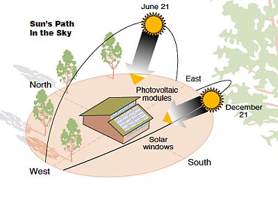
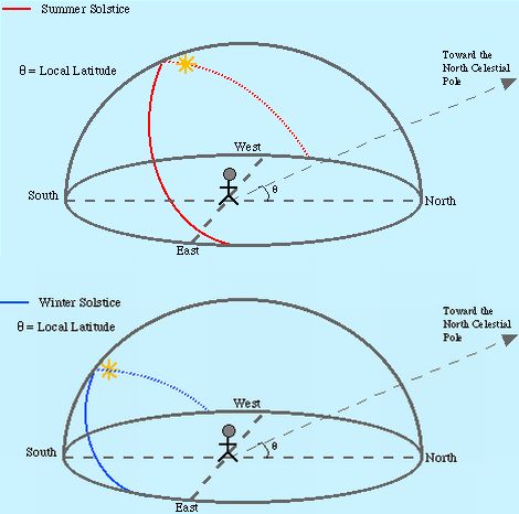
In the summer season the days are long and the Sun is high in the sky. The figure at the left shows the path of the Sun through the sky on the longest day of the year, the Summer Solstice (June 21). This is also the day when the Sun is the highest in the southern sky. Because the day is so long the Sun does not rise exactly in the east, but rises to the north of east and sets to the north of west allowing it to be in the sky for a longer period of time.
After the Summer Solstice the Sun follows a lower and lower path through the sky each day until it reaches the point where it is in the sky for exactly 12 hours again. This is the Fall Equinox (September 21). Just like the Spring Equinox, the Sun will rise exactly east and set exactly west on this day and everyone in the world will experience a 12 hour day. After the Fall Equinox the Sun will continue to follow a lower and lower path through the sky and the days will get shorter and shorter until it reaches its lowest path and then we are back at the Winter Solstice.
In the winter the days are short and the Sun in low in the sky. The shortest day of year falls on December 21 when the Sun is also lowest in the southern sky as shown in the diagram at the left. Each day after the Winter Solstice, which falls on December 21, the Sun’s path becomes a little higher in the southern sky. The Sun also begins to rise closer to the east and set closer to the west until we reach the day when it rises exactly east and sets exactly west. This day is called the Spring Equinox (March 21).
During the short winter days the Sun does not rise exactly in the east, but instead rises just south of east and it sets south of west.
The Spring and Fall Equinox in the Northern hemisphere.
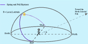
As explained above the Sun is at its lowest path in the sky on the Winter Solstice. After that day it progressively follows a higher and higher path through the sky each day until it is in the sky for exactly 12 hours (the Spring Equinox, March 21). On this day the Sun also rises exactly in the east and sets exactly in the west. Every place on earth experiences a 12 hours day twice a year on the Spring and Fall Equinox.
After the Spring Equinox, the Sun still continues to follow a higher and higher path through the sky, with the days growing longer and longer, until it reaches it highest point in the sky on the Summer Solstice.
Altitude and Azimuth
As explained above the path of the Sun changes throughout the year but its position in the sky can be defined by two angles: altitude and azimuth. Altitude tells how high the Sun is above the horizon: at Sunrise and Sunset, the Sun’s altitude is 0˚ above the horizon and about 90˚ around noon when the Sun is overhead. Azimuth describes the Sun’s position from east to west; it is the angle between true south and the point on the horizon directly below the Sun.
The Sun’s path also varies with latitude due to earth’s tilt; at locations further north (locations of greater latitude) the Sun’s path is lower in the sky. However, the arcs of Sun path are symmetrical about true south and solar noon. Solar noon is different from the clock noon: Solar noon is exactly midway between Sunrise and Sunset, which can be taken from the local newspaper of the same day. By definition, at solar noon the Sun shines from true south and thus the shadow cast by any object at solar noon will be along true south to true north and it is also the shortest.
The Solar Window
Solar photovoltaic modules must have a clear view of the sky as defined by the Sun’s apparent daily crossings. This is referred to as the solar window which should be kept free of shading from 9 AM to 3 PM solar time, when the maximum solar radiation is captured.
Looking at the year-long perspective, the altitudes of the Sun on December 21 and June 21 (the Winter and Summer Solstices) determine the upper and lower boundaries of the solar window. It can be safely assumed that if the long winter shadows near December 21 (when the Sun has its lowest altitude) do not shade the solar module, the shorter summer shadows will not shade the module either.
At low solar altitudes of the winter, the atmosphere, clouds, smog, and air pollutants can absorb or deflect considerable amounts of solar radiation. Solar altitudes below 15˚ (in the morning and late afternoon) are essentially useless for collecting solar power.
Tilt Angle
A solar collector or photovoltaic module collects the maximum solar radiation when the Sun’s rays strike it at right angles. As the solar collector or module is tilted away from perpendicular alignment to the Sun, less solar energy is received. However, small deviations away from the ideal tilt will not affect energy output much, and may be preferable from an appearance (as along the roof slope) or stability standpoint.
The optimal tilt angle for a solar energy system depends on both the latitude of the location and on nature of the application. Fixed modules and collectors that need to produce electricity and heat on a year-round basis are usually tilted at an angle equal to the latitude of the site. This angle points the collectors and modules directly toward the Sun in the spring and the fall when the Sun is at its midpoint position in the sky. Energy from the low winter Sun and the high summer Sun is not collected as efficiently, but the average yearly collection of energy is maximized.
Locating True North South with a Shadow Plot
A compass uses the earth’s magnetic field to find north and therefore points toward magnetic north, which is not in the same place as geographic north. But true north-south can be easily located with the help of a shadow plot for 3-4 hours around solar noon. This is based on the idea that at solar noon the shadow of an object is shortest and points along true north south direction.
A shadow plot can also help gain a feel for how the Sun’s path changes across the sky during the day. If it is plotted for several days (or weeks), one can gain first-hand knowledge that the path of Sun is always changing.
How to make a Shadow Plot
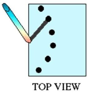
It involves planting a 2-3 feet long pole on the ground and marking its shadow at frequent intervals of time, say every 30 minutes. If solar noon is at 12.30 pm, it is best to start marking the shadow edge 1.5 – 2 hours earlier and continue 1.5 – 2.0 hours after the solar noon. This will give 6 – 8 points to reveal the pattern of shadow movement. It will appear something like the figure shown at the left. You will notice that the shadows are of different length. The shortest shadow points to geographic north. It will also be near the solar noon time. So this is the N-S line; a line perpendicular to it will be the E-W line.


No comments:
Post a Comment